SMART River Debris and the bigger picture
Technorati tags: Environment, Rivers, Malaysia, Flash Floods
From where I live, I get a clear view of Sungai Kerayong. Sungai what? (this is what Walski anticipates as the first thought to go thru yo' head). In case you're not familiar with KL geography, Sungai Kerayong is one of the feeder waterways that eventually makes its way to the great Klang River.
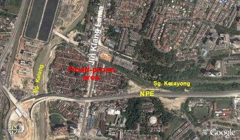
Last week, on Thursday, the residents of 4th Mile Jalan Old Klang Lama Road relived the dreaded flash flooding the area is well-known for.
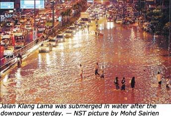
These days, flooding here doesn't occur as regularly as is used to - I believe the last time it happend this bad was about a year ago. But the question remains: Why should it be happening at all?
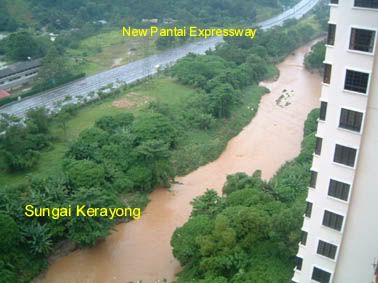
As mentioned, my balcony provides a very clear view of Sungai Kerayong, just before it passes by the 4th mile area of Jalan Klang Lama, and before it dumps its contents into the Klang River. One thing that's immediately noticable - the amount of debris that strewn along the grassy banks. Yesterday, it rained rather heavily all around the Klang Valley, and as usual when this occurs, Sungai Kerayong swells to above its normal level. The following picture was taken around 4 - 5pm.
In particular, this caught my attention (in the full post).
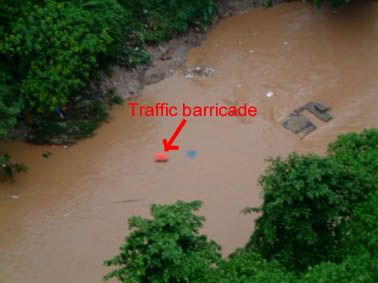
Now, from where, would a traffic barricade come from, that it would land up being swept away on Sungai Kerayong? And is river debris a factor causing our waterways to be clogged up to begin with? Not to mention unsightly.
As a matter of fact, it probably came from the SMART Tunnel project, of which Sungai Kerayong features prominently, since it will be where flood waters from the Taman Desa mining pool would be channelled out, in a "controlled" manner.
But in this case, Sungai Kerayong, which runs parallel to the stretch of the Sungai Besi Highway next to the TUDM base, obviously spilled its banks and flooded the construction area near the base, washing off the barricade - not necessarily on Saturday when the picture was taken, but likely on Thursday, when flooding along the Sungai Besi and Besraya Highways were also reported. Then, as all self-respecting river debris would, it broke its journey, stuck on the bank somewhere, just waiting for the next ride downstream - which happened to be on Saturday.
I have no problems with the SMART Tunnel Project, per se - HOWEVER, I'm just wondering if anyone has actually thought of using the Taman Desa storage reservoir outlet to Sungai Kerayong as an inlet instead, during heavy rains upstream and when the river swells badly. According to the SMART website FAQ section:
Wouldn’t discharging water from the storage reservoir at Taman Desa into Sg Kerayong causes flooding down stream?
The system works on principle of efficient monitoring. River monitoring instruments will be installed at the upstream of Sg Ampang and Sg Klang and Sg Kerayong at the downstream. As this system has a storage capacity of 3 million cubic meters, the diversion and release will be regulated according to the river capacity downstream. The capacity constraint at Sg Kerayong is incorporated into the system. Flooding downstream is thus not possible.
So, I guess, the answer would probably be... maybe since there's no mention of diverting Sungai Kerayong itself into the holding pond at Taman Desa, if need to. The project is scheduled for completion December of this year. For the sake of the folks around the 4th Mile Jalan Old Klang Lama Road, let's hope some forethought has been given. I guess we'll only know next April.
And let's hope that a chunk of the RM 500M allocated in the 9th Malaysia Plan for river rehabilitation won't need to be spent to implement an "afterthought" rectification. Wouldn't be very SMART if that were the case.